Severe Weather in the Plains

April 15, 2012

Not Out of the Woods Yet

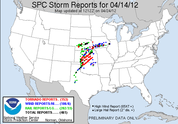
Wow!  Yesterday was just a colossal tornado outbreak.  It was one of those few times when everything came together to produce a large tornado outbreak.  In the end we got something like this:
My forecast certainly busted.  I don't think a lot of people anticipated the storms to initiate as early as they did.  If you look at the SPC's forecast, you'll notice that they kept expanding the high risk westward.  Unfortunately for me I didn't get a chance to update my forecast, so I ended up having my high risk area too far east.  While the Great Plains might be done with their activity for now, the US isn't out of the woods yet, as another dangerous day looks to be taking shape today, particularly across Western Wisconsin this afternoon and evening.  The SPC issued a Moderate risk today:
General
Tornado
Hail
Wind
What we have today is the low pressure system from last night moving northward.  As it does so there will be marginal instability developing across the moderate risk region.  That's one of the differences between today and yesterday.  Yesterday there was more instability to work with than today.  However, today has absolutely ridiculous wind fields, unlike yesterday.  The winds are so strong aloft that I would almost say that a storm would have severe winds as soon as it develops.  Add in the low level jet that will really ramp up tonight, we could be dealing with a squall line that stretches from Wisconsin down to the Gulf Coast.  Now there is little to no cap so storms should have no trouble developing into a line of severe thunderstorms this afternoon.  If a storm can remain semi-discrete, it may be able to produce a brief tornado given the ridiculous speed shear in the upper levels of the atmosphere.  This would be most likely in the Moderate risk area.  Taking this and a little bit more into account I got this:
Stay tuned!

Fermilab!

So as you know I went to the Fermilab tornado and severe storms seminar last night to view their 6 pm show.  It really was something.  There were multiple presentations on different aspects of all of the weather that can impact the US, with a focus especially on severe storms.  Every once in a while, Tom Skilling would give us updates on the tornado outbreak on the big screen as he showed us all of the websites we weather nerds like to use.  Then we got to see Jim Reed and his team as they were tracking a supercell that ended up plowing through southern Wichita with a tornado.  I stayed to see Jim Angel's presentation on tornado climatology, but then I left as it was already 10:30 and I was over an hour from home.  Earlier in the show, Jim Allsopp gave a very interesting presentation on severe weather preparation for large outdoor events.  All in all, it was an enjoyable evening, capped off by a really spectacular lightning show at 2 in the morning.  Unfortunately I was unable to brief you guys on severe weather, but the stuff we learned last night was still quite fun.  Stay tuned!

April 14, 2012

If I can I'll send updates we get on the outbreak at fermilab via txt message. If there is wifi I will follow the outbreak via iPod

Major Tornado Outbreak Today

Category: Severe Thunderstorms
Post Type: Quick Outlook
Urgency: PDS


I don't have much time this morning.  Basically, my coverage will be limited for today, as I will be out somewhere for most of midday, and then I will be at Fermilab starting at 6 pm tonight.  So it is gonna be tough to get much info out.  Here is my map for today:
Very dangerous day today.  Stay tuned!

April 13, 2012

VERY LARGE SEVERE THUNDERSTORM RISK TOMORROW!!!!!!!!!!!!!!!!!

Category: Severe Thunderstorms
Post type: Outlook/Warning Message
Urgency: PDS

Tomorrow has potential to be a very big day when it comes to severe weather.  For the first time in six years, the SPC issued a High Risk of severe thunderstorms the day before the event was supposed to happen.  Here is the map:
IF YOU LIVE IN THE RED OVAL, YOU NEED TO PREPARE!!!!!!  MAKE SURE THAT YOU HAVE A DISASTER KIT PUT TOGETHER FOR TOMORROW.  ALSO MAKE SURE THAT YOUR NOAA WEATHER RADIO IS PLUGGED IN AND HAS NEW BATTERIES INSIDE -- YOU NEVER KNOW WHEN THE POWER WILL GO OUT.  IF YOU DON'T HAVE ONE, YOU NEED TO GET ONE IN ORDER TO PROTECT LIFE AND PROPERTY.  MONITOR FORECASTS FROM THE STORM PREDICTION CENTER AND YOUR LOCAL NATIONAL WEATHER SERVICE OFFICE AND STAY ALERT!!!!!!

Quick Update on Severe Potential

Category: Severe Thunderstorms
Post Type: Update
Urgency: Take Action


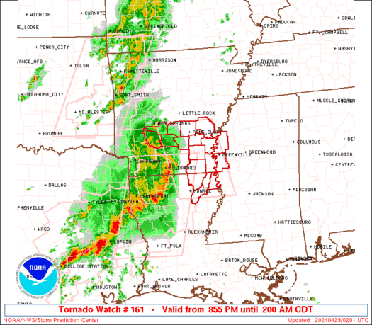
Hi guys!  We have a very dangerous situation ongoing in the Southern Plains currently.  There are multiple supercell storms moving through the region.  One of them is indeed tornado warned.  These storms have produced damage, and should continue to do so.  Let's get started.  The Storm Prediction Center (SPC) went against mine and many others' thinking and decided not to issue a moderate risk for severe thunderstorms, even though it appeared as though something like what is going now was going to develop.  We currently have two watches, one tornado and one severe thunderstorm:
Tornado Watch
Severe Thunderstorm Watch
The combination of high instability and medium wind shear should allow for storms to sustain themselves as severe multicell/embedded supercell thunderstorms.  Each storm that develops will have all of the tools necessary to become severe as storms are very spread out at this time.  Any storms that get strong enough to generate their own wind fields will definitely need to be watched.  Anvil level winds are actually pretty strong, so some storms that can become isolated could definitely develop some classic supercell characteristics.  As the low level jet ramps up this evening look for the tornado threat to increase some.  Definitely stay tuned, folks!

Weather Word of the Day

Today's word:  Storm Prediction Center
Definition:  The Storm Prediction Center is a center in Norman Oklahoma.  They are the ones that issue the severe weather outlooks that I always put near the top of each severe weather update type of post.  They also issue watches and Mesoscale Discussions.

Severe Weather Outlook for April 13, 2012

We yet again have a severe threat to deal with today.  Its really been a rough week for the Plains, with a lot of slight risks being issued.  I am sorry for my absence yesterday, I was on an all day field trip.  Anyway, back to severe weather.  The Storm Prediction Center (SPC) has issued a slight risk for severe thunderstorms:
General Outlook
Tornado Outlook
Hail Outlook
Wind Outlook
With a glance at those maps, I know that this is already looking like the most likely day for an upgrade to a moderate risk so far this week.  It appears that the SPC is really hitting it up on the hail threat for this afternoon.  After glancing at the models for this afternoon, it appears definite to me that there is a threat for supercells and tornados with tonight's event.  First of all, instability is sufficient to produce severe thunderstorms.  Also, there is plentiful shear for storms to really get going.  Another thing that I looked at is the fact that LCL heights are much lower to the ground than previous events this week have had.  LCL, or Lifted Condensation Level is basically where the temperature equals the dewpoint first.  It is a good indicator for how high the cloud base will be.  Today, LCLs are relatively low, so we can expect a couple of tornados across the risk area, particularly in Oklahoma.  Also, anvil level winds support High Precipitation to Classic supercells, with the latter being the most likely to produce a tornado, particularly strong ones.  Taking all of this into account, I got this:
I decided not to issue a moderate risk quite yet due to some uncertainty as to exactly what the main forcing is.  Also, the SPC has not issued a moderate risk yet, so I decided to just play it safe.  Please note however that this is a high end slight risk, and strong tornados are possible today.  If the situation warrants, I may upgrade this to a moderate in a *possible* update this afternoon.  For now, stay tuned!

April 11, 2012

Severe Weather Outlook for 04/11/2012

A slight risk of severe weather has been issued by the Storm Prediction Center (SPC) for today, April 11, 2012.  Here are the images:
General Threat
Wind Probabilities
Hail Probabilities
Tornado Probabilities 
As you can see, the SPC is aiming for a bulls eye in the Texas and Oklahoma Panhandle regions right now.  This comes as a convergence zone tries to develop in the Plains.  The main limiting factor for this severe weather event is the fact that moisture is actually limited today.  This really drags instability and thus the overall threat downward for today.  There is actually enough shear and dynamics to potentially push a few a few supercells into developing, however, I am not seeing a widespread threat with this.  However, if we can get a lone supercell to show itself, and it just happens to be in the zone of maximum shearing, we could get something going.  As nightfall comes, we should get a cluster or two of storms to develop bringing with it the always present threat of damaging winds.  So taking this all into account, I get this:
Stay tuned!