I am sure all of you are asking the above question. When will winter return? At this point, it's kind of sketchy. While I am still thinking this will be a cold winter across the eastern USA, I am starting to think that it will have a late start. In order to forecast things over the long range, you need to know what teleconnections, or high pressure/low pressure patterns, are doing. At this point, teleconnections are very unfavorable for any persistent cold. And it looks like it will stay that way. The first image I have for you shows two very important teleconnection indices, the PNA and the NAO, forecasted by two weather industries:

The top two images are the two weather forecasts for PNA, and the bottom two are for the NAO. Let's talk about the PNA first. In a nutshell, a positive PNA is what we want for cold/snow during the winter for the eastern USA. But as you can see in the top two images, the PNA is WAY negative. This has been preventing the cold from really getting going. There is some hope, however, that we will see a return of at least a neutral PNA by the end of the month. This notion is supported by the right image, but the left image shows a continued negative PNA. Time will tell which one occurs. The NAO isn't as important at this time because it'll be sitting at around neutral come the end of the month. Some models have it going negative, but I am not buying it quite yet. So basically we are waiting to see when the PNA will go negative, right? Wrong. Another important index is the MJO, or Madden Julian Oscillation. Here is the latest NCEP GEFS forecast:
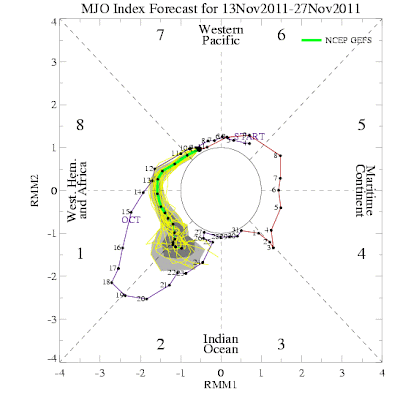
It is expected to go into phases 8, 1, and 2. These favor cooler and stormier conditions over particularly the Central USA. Will this spark the pattern change we're waiting for? Time will tell. Stay tuned!


No comments:
Post a Comment