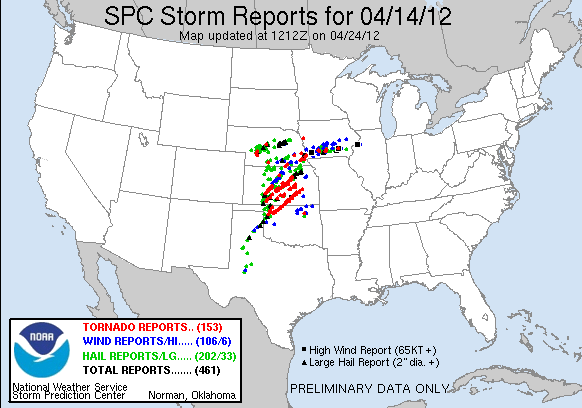
Wow! Yesterday was just a colossal tornado outbreak. It was one of those few times when everything came together to produce a large tornado outbreak. In the end we got something like this:
My forecast certainly busted. I don't think a lot of people anticipated the storms to initiate as early as they did. If you look at the SPC's forecast, you'll notice that they kept expanding the high risk westward. Unfortunately for me I didn't get a chance to update my forecast, so I ended up having my high risk area too far east. While the Great Plains might be done with their activity for now, the US isn't out of the woods yet, as another dangerous day looks to be taking shape today, particularly across Western Wisconsin this afternoon and evening. The SPC issued a Moderate risk today:
 |
| General |
 |
| Tornado |
 |
| Hail |
 |
| Wind |
What we have today is the low pressure system from last night moving northward. As it does so there will be marginal instability developing across the moderate risk region. That's one of the differences between today and yesterday. Yesterday there was more instability to work with than today. However, today has absolutely ridiculous wind fields, unlike yesterday. The winds are so strong aloft that I would almost say that a storm would have severe winds as soon as it develops. Add in the low level jet that will really ramp up tonight, we could be dealing with a squall line that stretches from Wisconsin down to the Gulf Coast. Now there is little to no cap so storms should have no trouble developing into a line of severe thunderstorms this afternoon. If a storm can remain semi-discrete, it may be able to produce a brief tornado given the ridiculous speed shear in the upper levels of the atmosphere. This would be most likely in the Moderate risk area. Taking this and a little bit more into account I got this:

Stay tuned!

No comments:
Post a Comment