
"Your weather authority"
Showing posts with label cold blasts. Show all posts
Showing posts with label cold blasts. Show all posts
December 27, 2011
Big Snows in Our Near Future?
The ECMWF and the GFS both have big snows coming soon, around New Years. The question is whether or not they're correct and if so, what will the track be. We are going to be showing you images from the GFS model. The ECMWF shows a stronger storm, but I currently think that the GFS is more plausible at this time with the way it works things out with the way the storm works out after it is gone. The GFS has a storm quickly developing before moving right on out, and that's what I think is more likely with the way this pattern is going, with now major changes indicated currently. As always, something drastic could happen, but I am not counting on it as of right now. That being said, let's look at the GFS model from 12z at hour number 150:
 The GFS shows a low pressure area developing before quickly moving out. Behind it, a trough of cold air develops, but it quickly gets out of the way for yet another ridge set to move in. At this point, I like this solution due to the pattern that we are currently experiencing, and the little signs of significant change that I see right now. The ECMWF shows a storm system marching up the coast, putting down a lot of snow across the east. Time will tell which model comes true, if any. But for now, stay tuned!
November 28, 2011
Snowy Weather Possible for the Ohio Valley
It looks like a storm system will begin its trek through the Ohio Valley today, bringing with it potential for accumulating snow. Uncertainties still exist as some models don't really show snow accumulations, and I'm not even sold on it. That's why the title of this post and all of my maps will say possible on them. First let's start off with today. The HPC is hinting at a very slight possibility for more than four inches of snow:
 While only a ten percent chance for greater than four inches of snow doesn't seem like a lot, it's very big for those areas, especially in November. Here is USA Weather's official map:
 Not a wide range in accumulations, so I just put out one color area for the whole thing. This one could come as a surprise, as people in this region don't usually experience snow until later in the year. Of slightly greater concern is when this storm tracks through the Ohio Valley. Here is my map:
 Three to six inches is possible in the light blue region, with higher amounts in the darker blue area. It looks like a fun storm! Later on into next weekend, it looks like another storm will move through with potential for a few inches of snow. Behind that, a strong cold blast will move through. Just another tidbit to look forward to. Stay tuned!


November 14, 2011
When Will Winter Return?
I am sure all of you are asking the above question. When will winter return? At this point, it's kind of sketchy. While I am still thinking this will be a cold winter across the eastern USA, I am starting to think that it will have a late start. In order to forecast things over the long range, you need to know what teleconnections, or high pressure/low pressure patterns, are doing. At this point, teleconnections are very unfavorable for any persistent cold. And it looks like it will stay that way. The first image I have for you shows two very important teleconnection indices, the PNA and the NAO, forecasted by two weather industries:
 The top two images are the two weather forecasts for PNA, and the bottom two are for the NAO. Let's talk about the PNA first. In a nutshell, a positive PNA is what we want for cold/snow during the winter for the eastern USA. But as you can see in the top two images, the PNA is WAY negative. This has been preventing the cold from really getting going. There is some hope, however, that we will see a return of at least a neutral PNA by the end of the month. This notion is supported by the right image, but the left image shows a continued negative PNA. Time will tell which one occurs. The NAO isn't as important at this time because it'll be sitting at around neutral come the end of the month. Some models have it going negative, but I am not buying it quite yet. So basically we are waiting to see when the PNA will go negative, right? Wrong. Another important index is the MJO, or Madden Julian Oscillation. Here is the latest NCEP GEFS forecast:
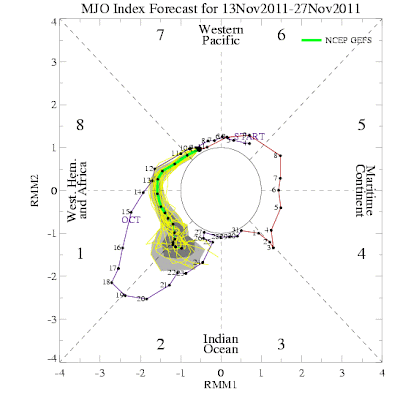 It is expected to go into phases 8, 1, and 2. These favor cooler and stormier conditions over particularly the Central USA. Will this spark the pattern change we're waiting for? Time will tell. Stay tuned!


November 04, 2011
When Will Winter Come?????
THIS POST IS OUT OF DATE!!!!!! REFER TO this post.
I know that a lot of you out there are snow lovers, and you are getting tired of the "warm" weather. I also am willing to bet that a lot of people who read this blog are snow haters. We all know that across the northern regions, snow is inevitable. Eventually, winter will sweep over, and snow will cover the ground. At this point, the question is when. Well, we are already seeing signs that the atmosphere is gearing up for a big cold blast, one that may potentially last through the winter. First of all, the NAO, or North Atlantic Oscillation, has been positive over the last few months. This has allowed cold air to build in the Arctic and Western Canada:
 However, it is starting to look like a turn to a negative NAO is coming. This will allow for the cold air that has been building up to spill southward through the United States. Models are also showing the Greenland Block making a return, which generally leads to cold in the United States. Let me show you what the models think is coming in the 8-10 day time frame:
 I want you first to know that you should not take these maps for given, considering this a long ways out. The arrival time is likely to be delayed a little bit. I want you to pay particular attention to the GFS model's interpretation (on the right). It is a perfect example of the Greenland block. We see a lot of blocking in Greenland, causing cold air to spill southward into the US. Again, the question isn't if, but when. The NAO may hold a clue to that. The GFS ensembles are showing the NAO diving negative over time:
 This would result in some cold air across the eastern USA. In summary, it looks like the NAO will go negative, and the country will turn cold. The question is when. While the models are showing this pattern change arriving in the next 1-2 weeks, I think it may wait until about halfway through November before we truly get cold. Don't despair snow lovers! Stay tuned!
I know that a lot of you out there are snow lovers, and you are getting tired of the "warm" weather. I also am willing to bet that a lot of people who read this blog are snow haters. We all know that across the northern regions, snow is inevitable. Eventually, winter will sweep over, and snow will cover the ground. At this point, the question is when. Well, we are already seeing signs that the atmosphere is gearing up for a big cold blast, one that may potentially last through the winter. First of all, the NAO, or North Atlantic Oscillation, has been positive over the last few months. This has allowed cold air to build in the Arctic and Western Canada:


October 20, 2011
Update on the Major Storm
Well the current major storm is ongoing right now. It is producing a large area of rain, a swath of winds, and a punch of brutally cold air behind it. The first thing that we are going to look at is a combination of the current sea level pressure and some infrared satellite imagery:


This map easily shows us the strength of this storm along with the large rain band to the north and west of our storm. This is a classic storm right now. If it were winter, we'd likely see widespread 12+" readings associated with this low, along with blizzard conditions. Fortunately, we are not currently in winter. However, if a storm like this can occur in October, it can occur in the winter too. Continuing on, let's look at the QPF made by the Hydrometeorological Prediction Center:

We can see that our swath of heaviest rain (or maybe even snow) will move up into Canada today, with precipitation totals nearing 1.5 inches expected. At this point, the bigger story may be the cold air behind this storm. Check out the latest map from the National Weather Service:

See all of that blue inside of my red circle? Those are warnings regarding cold air! They extend all the way into Alabama! Here is tonight's expected low:

And tomorrow night's expected low:

That's all I have for you right now, stay tuned!
October 18, 2011
ANOTHER Big Storm?
While this current storm that we are dealing with definitely has not lived up to hype by means of snow, it will be followed by another storm that could bring some wickedly cold air around Halloween weekend. For right now, I won't get into specifics, however a bigger update may become necessary this afternoon. Stay tuned!
September 15, 2011
Cold Blast
Obviously it has been quite chilly across the northern plains into the Midwest over the past 24 hours, with our headquarters noting frost developing in open areas around here, including outside of our building. Time is limited this morning, so I really don't have the normal detail I hope to bring back today. Tomorrow morning I will be in better shape. That's all I have, stay tuned!
Subscribe to:
Comments (Atom)