
"Your weather authority"
Showing posts with label gfs. Show all posts
Showing posts with label gfs. Show all posts
December 27, 2011
Big Snows in Our Near Future?
The ECMWF and the GFS both have big snows coming soon, around New Years. The question is whether or not they're correct and if so, what will the track be. We are going to be showing you images from the GFS model. The ECMWF shows a stronger storm, but I currently think that the GFS is more plausible at this time with the way it works things out with the way the storm works out after it is gone. The GFS has a storm quickly developing before moving right on out, and that's what I think is more likely with the way this pattern is going, with now major changes indicated currently. As always, something drastic could happen, but I am not counting on it as of right now. That being said, let's look at the GFS model from 12z at hour number 150:
 The GFS shows a low pressure area developing before quickly moving out. Behind it, a trough of cold air develops, but it quickly gets out of the way for yet another ridge set to move in. At this point, I like this solution due to the pattern that we are currently experiencing, and the little signs of significant change that I see right now. The ECMWF shows a storm system marching up the coast, putting down a lot of snow across the east. Time will tell which model comes true, if any. But for now, stay tuned!
November 22, 2011
Potential Increasing for Snow Next Week across Great Lakes
Now before I set off an alarm, I have to say that this is still a whole week away, and plenty can change. So don't take anything I say here as true, but stuff that has potential to happen. Now, let's get started. This will all start around the weekend after Thanksgiving. On Saturday the 26th, an area of low pressure moves up, producing warm air and showers across the Western Great Lakes:
 By the following Tuesday, however, the GFS shows that cold air moves southward, creating a snowy situation for folks across the Western Great Lakes:
 The snow would in general be light, however accumulation would most certainly be possible, especially if a bout of heavier snow occurs in association with any possible embedded storm systems. The snow was looking even worse for these areas yesterday afternoon, and there is no reason to say it won't go back to that. Stay tuned on this one.


November 08, 2011
Heavy Rain Likely across Midwest through Wednesday
A threat for very heavy rain has developed for areas across the Midwest. To see the totals the experts are calling for look at this map:
 We are expected to get nearly 2.5 inches of rain here in Northern Illinois. The most rain will be in Southeast Wisconsin, where the expected high amount is nearly 3 inches. Wow. The GFS has backed off a little bit on the expected intensity, but still a lot of rain is expected. Stay tuned.

November 04, 2011
When Will Winter Come?????
THIS POST IS OUT OF DATE!!!!!! REFER TO this post.
I know that a lot of you out there are snow lovers, and you are getting tired of the "warm" weather. I also am willing to bet that a lot of people who read this blog are snow haters. We all know that across the northern regions, snow is inevitable. Eventually, winter will sweep over, and snow will cover the ground. At this point, the question is when. Well, we are already seeing signs that the atmosphere is gearing up for a big cold blast, one that may potentially last through the winter. First of all, the NAO, or North Atlantic Oscillation, has been positive over the last few months. This has allowed cold air to build in the Arctic and Western Canada:
 However, it is starting to look like a turn to a negative NAO is coming. This will allow for the cold air that has been building up to spill southward through the United States. Models are also showing the Greenland Block making a return, which generally leads to cold in the United States. Let me show you what the models think is coming in the 8-10 day time frame:
 I want you first to know that you should not take these maps for given, considering this a long ways out. The arrival time is likely to be delayed a little bit. I want you to pay particular attention to the GFS model's interpretation (on the right). It is a perfect example of the Greenland block. We see a lot of blocking in Greenland, causing cold air to spill southward into the US. Again, the question isn't if, but when. The NAO may hold a clue to that. The GFS ensembles are showing the NAO diving negative over time:
 This would result in some cold air across the eastern USA. In summary, it looks like the NAO will go negative, and the country will turn cold. The question is when. While the models are showing this pattern change arriving in the next 1-2 weeks, I think it may wait until about halfway through November before we truly get cold. Don't despair snow lovers! Stay tuned!
I know that a lot of you out there are snow lovers, and you are getting tired of the "warm" weather. I also am willing to bet that a lot of people who read this blog are snow haters. We all know that across the northern regions, snow is inevitable. Eventually, winter will sweep over, and snow will cover the ground. At this point, the question is when. Well, we are already seeing signs that the atmosphere is gearing up for a big cold blast, one that may potentially last through the winter. First of all, the NAO, or North Atlantic Oscillation, has been positive over the last few months. This has allowed cold air to build in the Arctic and Western Canada:


October 22, 2011
Snowstorm Next Week?
That's right folks, we are looking at the potential for the first all out snowstorm to hit to hit the eastern US of the season. We are still in the preliminary stages of forecasting this event, and a lot of things could change. Here is the GFS at hour 156:
 We can see a well defined storm with a lot of moisture to work with. Lower Michigan could easily see a significant storm (6+") if this were to happen during the weekend. The only problem is temperatures. The fact is that this storm may end up producing more of a rain/snow/ice mix than anything else in the main area of precipitation. Plus, even if it does snow, the ground temperatures may end up being too warm. We may still end up seeing a few inches of snow on the back side though. This is definitely a storm to watch, and I will definitely have more updates later on as this does have potential to impact some daily activities. Stay tuned!

October 20, 2011
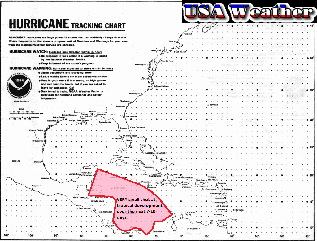
Tropical Troubles?
The CMC model is gaining support from the models for a storm in the next 7-10 days. I still like the map that I made yesterday (find it here), so I am just going to show you the updated model forecasts. Here is the CMC's picture at hour 126:
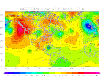 We see a strong storm sitting in the Caribbean. Now here is the GFS at hour 114:
 I will leave you to make what you want of these maps, as the discussion from last night is still pretty much valid. Stay tuned!


October 18, 2011
ANOTHER Big Storm?
While this current storm that we are dealing with definitely has not lived up to hype by means of snow, it will be followed by another storm that could bring some wickedly cold air around Halloween weekend. For right now, I won't get into specifics, however a bigger update may become necessary this afternoon. Stay tuned!
October 11, 2011
GFS Snow System Update
Well the GFS has been consistent with its low pressure system, and with the fact that snow may be on the back side of it. Now, the ECMWF has finally sided with the GFS, as we woke up to this picture which is about 192 hours into the future:
 Unfortunately this model does not show precipitation this far out. We aren't going to go into specific snow amounts quite yet, but the fact that we are getting consistency with the models is just making snow more and more likely for the Midwest/Great Lakes region. Stay tuned!

October 10, 2011
GFS Snow System
Well, last night I was looking at the models and I found that the GFS was producing a snowy solution, bringing a low originating in the Rockies through the Plains and Upper Midwest with some snow on the backside of it. Nothing huge, maybe 2-4" at best, but it was certainly interesting to look at. This morning, I found it again. This time, the track was farther south. This is valid about midnight on the morning of Tuesday, October 18th. Here it is:
 Just so you know, this image is 192 hours out. This time frame isn't in total model lala land, but it's getting close. In simple terms, expect this solution to change. As we analyze the image, it is apparent that there simply isn't enough moisture to produce a heavy snowfall with this system. My best guess would be about 1.5" up to maybe 3". And again, we do expect this to change. Here is Twisterdata.com's GFS snowfall map:
 We can see about an inch of snowfall being painted in the heaviest snow area. I will be checking up and tracking this storm throughout the week, so expect more updates. Stay tuned!


Subscribe to:
Comments (Atom)