"Your weather authority"
Showing posts with label tropical wx. Show all posts
Showing posts with label tropical wx. Show all posts
November 22, 2011
Tropical Threat Dead in Atlantic
The Atlantic tropical threat that I posted yesterday has pretty much died as the NHC reduced the threat for development all the way down to 10%. Stay tuned!
Major Hurricane Kenneth Update
Hurricane Kenneth really wanted to make his presence known, as he strengthened into a very dangerous major hurricane. Here are the latest images from Kenneth. They WILL update with time:
Stay tuned!
 |
| Satellite |
 |
| NHC's forecast track |
 |
| NHC's expected wind speeds |
November 21, 2011
Dual Tropical Troubles
We have an interesting situation this morning, as there is a dynamic duo of tropical systems. One in the Pacific, and one in the Atlantic. Let's start in the Pacific. Here we find Tropical Storm Kenneth. Kenneth has a minimum central pressure of 995 millibars and maximum sustained winds of 65 mph. Kenneth is actually a very interesting beast, as not since December 4, 1983, has a tropical storm formed in the Eastern Pacific this late. Here is a satellite image:
 It isn't the most organized storm, but that is kind of expected as it has yet to really get intense. We aren't seeing any major land masses in the way of this storm, and the NHC's latest track sums that up:
 Although it is no threat to land, ships should still look out for it, as it is forecasted to become a hurricane:
 All right, now we shift our focus to the Atlantic Ocean. Here, the NHC has labeled a high chance of development in the next 48 hours:
 This is not your ordinary storm, as the NHC has this up for the potential to develop into a subtropical cyclone. This would have to happen soon, as there is a small window for this thing to develop before it moves over cooler waters. Stay tuned.


November 09, 2011
Subtropical Storm Sean
Subtropical Storm Sean developed in the Atlantic, bringing with it 50 mph winds and a 995 mb central pressure. It is expected to move northeast, as shown in this map:


This storm is not expected to directly affect the US, but it will bring Bermuda tropical storm conditions. Bermuda is currently under a tropical storm warning. Here is the probability that winds will exceed tropical storm force because of this storm:

We can see that Bermuda has at least a 30% chance at seeing tropical storm force winds. If the track stays the same, then these will only increase. Here is the maximum wind forecast from the NHC:

We can see that after a peak of 60 mph, Sean will slowly decrease in intensity. Bermuda folks will definitely need to watch this storm. Stay tuned!
October 28, 2011
Tropical Storm Rina Update
Rina is still churning in the Atlantic, battering the island of Cozumel. Here is the NHC's current track followed by their wind speed forecast:

 At this time, this system remains little threat to Florida. It should become post-tropical over the weekend, and that is when we will stop updating you on this storm. Stay tuned!


October 27, 2011
Hurricane Rina Update
Hurricane Rina is still churning in the Caribbean as of this morning. She is barley clinging on to hurricane strength, and is expected to dwindle in intensity over the next few days. Here is her track:
 She is expected to turn southward in the next few days, and the chances of her hitting Florida are falling. Stay tuned!

October 24, 2011
Tropical Storm Rina
Tropical Storm Rina has officially formed in the Caribbean Ocean. We have very little time this morning, so this won't be a detailed post at all. I will have more this afternoon, but for now, let me get you guys briefed on this system with the NHC's current track and wind probabilities:
Stay tuned!
 |
| Track |
 |
| Wind Probabilities |
October 22, 2011
Uncertain Tropical Threat
Right now we are concerned about a tropical system in the Caribbean. It currently has a 60% chance to develop, but an uncertain future. Here is the current spaghetti model forecast track plot:
 The uncertainty is great. A few models have it moving into Central America, while one has it moving straight into Florida. But the general consensus is that it will slowly move about before moving into the Yucatan Peninsula of Mexico. Because the track forecast is so uncertain, and because intensity depends on the track, we will not show the intensity forecast at this time. This will certainly become an interesting situation to watch. Stay tuned!

October 20, 2011
Tropical Troubles?
The CMC model is gaining support from the models for a storm in the next 7-10 days. I still like the map that I made yesterday (find it here), so I am just going to show you the updated model forecasts. Here is the CMC's picture at hour 126:
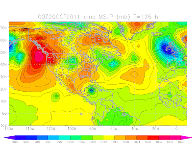 We see a strong storm sitting in the Caribbean. Now here is the GFS at hour 114:
 I will leave you to make what you want of these maps, as the discussion from last night is still pretty much valid. Stay tuned!


October 19, 2011
No Tropical Weather Currently, But a Storm is Possible Soon
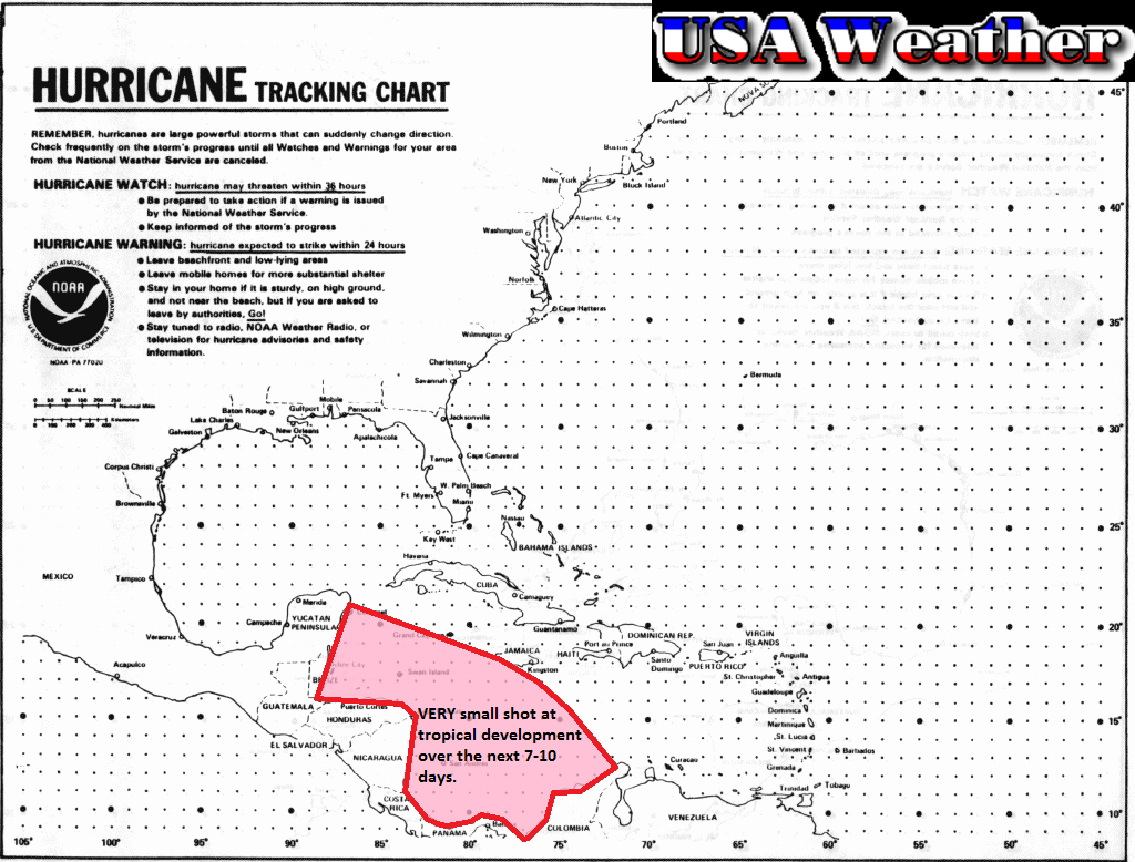
There is currently nothing to watch in the tropics in either the Eastern Pacific or Atlantic basins. However, a couple of computer models are suggesting that a small storm could develop in the Caribbean. At this time it is unlikely for a storm to form. We went ahead and made a map for you guys just so you can see the area we are watching:
 The chance is very small as I already said. A few models are hinting at the tropical wave sitting in this area, but not developing it. In fact, at this time, only one model is developing this into a legitimate storm at this time, and it is the CMC, a computer model that is usually is way too aggressive. In other words, a storm this strong or even a storm in general is unlikely. Here is the image:
 What I am talking about is that swirl of isobars just south of Cuba. That's all I have for now, stay tuned!

October 18, 2011
Very Small Chance of Development
The system we've been talking about for the past couple of days is about dead, with the NHC only giving it a 0% chance for development. No need for an extensive update here. This will likely be the last post regarding this system in its tropical form. As you may know by now, this will combine forces with another storm to produce a monster across the Northeast this week. Stay tuned!
Chances for Tropical Development decreasing rapidly
The NHC has downgraded their chance for development on the system in the Caribbean down to 10%. At this point, it is doing exactly what I told you it would do. It is becoming extratropical. Here is the latest map of the area:
 At this point, we are not too worried about tropical development at all. However, this system is expected to merge with another system in the Midwest, creating a Nor'easter that will ride up through the Mid-Atlantic, bringing heavy rains and mountain snows. Here is the latest Quantitative Precipitation Forecast, or QPF, from the HPC:
 This will certainly become an interesting situation, and we will update you on it as updates come in. Stay tuned!


October 17, 2011
New Tropical Threat?
We are currently watching a system that has developed off the coast of Yucatan, as it currently has a 60% chance of developing in the next 48 hours. After this time period, however, the NHC indicates that upper level winds will become unfavorable for development. Will get to this more in a minute. First, the NHC's map of the area:


The visible satellite imagery shows a well-defined system that should be able to develop, and the infrared is the same:

There is one problem: wind shear. Currently, this system is surrounded by an area of strong shear, according to CIMSS. Shear is detrimental to tropical storm production. Here is the map:

The location of the system is just off of the Yucatan Peninsula, in case you were wondering. The GFS model is indicating that the upper level winds will indeed become unfavorable for development soon. So what does this mean? I think that we will see a tropical storm develop, but it should become extratropical before it reaches land. Here is my current projected path:

This should be similar to the "Unnamed Storm" that hit Florida last week. That's all I have for now, stay tuned!
September 14, 2011
Tropicast: 09/14/2011
We are going to do a general tropical update today, due to the fact that Maria is little threat to the US. Again, Maria remains a low threat to the US, so we won't be doing a detailed update on her. In fact, both the US basins look like they will be relatively inactive for a while. While no one can rule out a little storm developing out of nowhere, the overall look to it is that we will be relatively quiet. Stay tuned!
August 12, 2011
Tropicast: 08/12/2011
The server has come back up, yet Norton Security System thinks that one of the websites is attacking my computer, which I know it's not. Sigh... Anyway, I can access that website in another browser, so I am only losing convenience here. Continuing, we have four invest areas this morning. I have them labeled here:
 In the short term, Invest 95L has the highest chance of development, with a few other systems possibly coming into play in the near future. As of right now, the system we have to worry about the most for potential to impact the US is definitely 93L. The very last thing we need is a hurricane with economic rollercoaster we've seen over the past few days, and this system has potential to bring one. Of course, we are still at least a week away from that happening, and the details are slim. Stay tuned!

August 11, 2011
Invest 93L
Invest 93L has, in the long run, a higher chance of development than 92L, and is likely to be more intense than 92L. Invest 93L is even closer to the African coast, so again we must use the METEOSAT satellite data:
 This storm looks like it is battling some shear based on satellite, which may impede development over the next few days. However, once it does develop, this should develop into a hurricane. It will be interesting to watch how this situation develops over the next few days. Stay tuned.

Invest 92L
As promised, we are breaking down into sister posts, with one for 92L, and one for 93L. This one is for Invest 92L. One of the unique aspects of these storms is the fact that they are so far east -literally just off of Africa- that we can't get any satellite imagery from GOES (NOAA's satellites) at this time, simply because they are in a region that is not covered. Instead, we rely on METEOSAT for the latest satellite data until these storms come within reach of GOES. Here is Invest 92L:
 It looks okay, but it isn't quite organized yet. This system may battle shear and dry air over the next few days, but once it gets into a clear zone, look out, 'cause this should become our first Atlantic hurricane of the season, assuming it develops. As of right now, it looks like it should miss the U.S. coast, but if it doesn't develop until really late for some reason, things could become more interesting. The biggest question right now with this storm is whether or not it will develop. If it does develop, we could be dealing with a hurricane, so watch out, and stay tuned.

Tropicast: 08/11/2011
Well today looks a lot more interesting tropical Atlantic wise than it has at all this season, even without any named storms. With Accuweather describing the situation as "Locked and Loaded," we should probably prepare for an interesting couple of weeks. As of right now, there are two areas of Investigation. We have Invest 92L, with a 30% chance of development, and Invest 93L, with a 20% chance of development. The NHC tracks the waves here:
 The one off the coast of Florida can be disregarded, as the threat for development remains very low. Off of Africa, the orange one is 92L, while the yellow one is 93L. Because there is a lot to talk about these two systems, I will end this Tropicast here and give the two Invests their own posts. Stay tuned!

August 10, 2011
Tropicast: 08/10/2011
The only thing of interest today is Invest 92L because of its potential to become the first hurricane of the Atlantic season. As of right now, the system has only a 20% chance of development per the NHC:
 However, they do mention that there is potential for slow development of this system over the next few days. This is where the uncertainty kicks in. IF it develops, and that is a big if, we could be dealing with a hurricane this weekend out in the Atlantic. It would likely stay away from the U.S. However, a few models actually keep this thing as a tropical wave, with no development. A couple of models are showing this thing cutting into the Gulf of Mexico, so although it should track away from land, we still need to watch this feature. STay tuned.

August 09, 2011
Notice
Because of the very low tropical threat, I will not be issuing a tropical forecast today. Stay tuned.
Subscribe to:
Comments (Atom)